
Friday, October 29, 2010
Inconceivable!

I told people that I'd spent most of last week sticking my head out the window, yelling, "Inconceivable!" Storm after storm passed by, edging just to the north or just to the south.
How this line missed us, I have no idea. Storms here generally march from left to right, or rather, west to east. We are in the area outlined by the white box, yet once again, we didn't get a drop of rain. Inconceivable!
Wednesday, October 27, 2010
Joslin Rendezvous :: The Homestead
If you had been a young man eager to begin a new life back in the early 1900s and you saw something like this photo below, would you have invested several years of your life trying to make a go of it?

South of Murdo in Mellette County, South Dakota
Twenty-five year old Virgil Newton Joslin did just that in 1916. Tired of working for other men he was determined to have a place of his own. He took up homesteading in west-central Mellette County, South Dakota, almost on the eastern edge of The Badlands. His first abode on the homestead was a dugout in the side of a hill. About the same time or shortly thereafter, his parents Luther and Phoebe (Elliott) Joslin joined him on the homestead. Two years later Virgil married Mary Matilda Hutcheson and he built what he called a “tar paper shack.” It was 12x16 feet, constructed of boards and covered in tar paper that was normally used for covering a roof before the shingles are put down.
Soon a son, Irwin, was born. In 1922, the tar paper shack was replaced by the beginnings of a “real” house - a concrete basement. A few years later a daughter was added to the family and then two more sons – Ruth, Jim, and George were all born in the nearest "large" town, White River.
A barn was built. A dam was constructed across a stream and a pond was dug. Virgil and Mary worked hard on their homestead. His parents helped as much as they could. Virgil still had to work for other men to help feed his growing family.
The dream house was never built. The family was caught up in the wrath of Mother Nature. It started with a prolonged drought. Irwin tells about the conditions in the early 1930s in his memoirs:
In October 1986, 50 years after the family left Mellette County, South Dakota the four children of Virgil Joslin “revisited” their homestead. Over the years they returned several more times. George and his wife Lorene made a visit there in September of last year and learned that Mellette County was going to have its Centennial Celebration this year. Descendants of the early homesteaders were invited to return. George and Jim began planning the trip and invited me to join them. I'd heard so much about “The Homestead” that I just had to see it for myself!

I was standing a ways south of where the basement house was located, looking to the north. George was trying to determine where the barn had been – he's standing a little right of the center of the photo.

Hardly a trace of the buildings remain – just a few pieces of concrete where the basement house was dug out. Fred is walking down into the hole where the basement was. It is partially filled with debris and junk. When they were here in 1991, they could still see the square walls of the basement, which have begun to cave in.

Looking to the west from the location of the house.

The pond that Virgil dug out. It lies to the north of the house, below the hill.

The view to the East.

And, looking toward the south.
I was quite surprised to see so much green grass, especially this late in the summer, but it has been an unusually wet summer in South Dakota this year, unlike some areas of the country that are experiencing a prolonged drought. It does look inviting. Coming from a land with an abundance of trees and lakes and streams, I enjoy visiting these “desolate looking” places but I would find it difficult to live here. The folks that do have my admiration even if I do think they are a bit crazy!

The Joslin Clan – standing - Richard (descendant of Luther's daughter Phoebe), Me (descendant of Luther's sister Malissa), Tim (son of George), Babs (daughter of Irwin), Joann (daughter of Ruth), Fred (husband of Sue), Sue (daughter of Ruth). Seated are George, Ruth and Jim (children of Virgil). Irwin passed away in 1990. Ten people came from six states: Alabama, Colorado, Indiana, Louisiana, Missouri and Virginia!
Photographs taken August 20th and 21st.
Update August 30, ..: Sue has additional photos of the visit to White River on her blog. Also, see her post The Homestead Tour.
South of Murdo in Mellette County, South Dakota
Twenty-five year old Virgil Newton Joslin did just that in 1916. Tired of working for other men he was determined to have a place of his own. He took up homesteading in west-central Mellette County, South Dakota, almost on the eastern edge of The Badlands. His first abode on the homestead was a dugout in the side of a hill. About the same time or shortly thereafter, his parents Luther and Phoebe (Elliott) Joslin joined him on the homestead. Two years later Virgil married Mary Matilda Hutcheson and he built what he called a “tar paper shack.” It was 12x16 feet, constructed of boards and covered in tar paper that was normally used for covering a roof before the shingles are put down.
Soon a son, Irwin, was born. In 1922, the tar paper shack was replaced by the beginnings of a “real” house - a concrete basement. A few years later a daughter was added to the family and then two more sons – Ruth, Jim, and George were all born in the nearest "large" town, White River.
A barn was built. A dam was constructed across a stream and a pond was dug. Virgil and Mary worked hard on their homestead. His parents helped as much as they could. Virgil still had to work for other men to help feed his growing family.
The dream house was never built. The family was caught up in the wrath of Mother Nature. It started with a prolonged drought. Irwin tells about the conditions in the early 1930s in his memoirs:
“For two or three years there was not enough rainfall to produce crops. Then the wind, which always blows in South Dakota, began picking up the dirt from the dry fields and we had dust storms. They might not have been as bad as in the Oklahoma dust bowl, but I recall them lasting for 2-3 days and the fine dust was everywhere...It literally blew all the dirt out of the fields as deep as it had been plowed.”
“In addition to the drought, depression and dust storms we had plagues of insects. Beetles overran the place once and ate anything green that was growing. Another year it was grasshoppers – the big kind that fly. They were so thick that, at times, when they flew over they made a shade like a cloud. they ate everything – even the dried bark off fence posts that had been in the ground for years. They also ate pitch fork handles because of the salty taste of perspiration from our hands.”
“During these times my father did as everyone else did, and kept borrowing money from the local bank and giving livestock and farm implements as collateral. The taxes on the land couldn't be paid in these years either. Everyone hoped for a better year – next year. but it came too late for most of them – their resources ended. My father finally had to just turn it all over to the banker and let the land go back for unpaid taxes. Then we left the homestead.”In 1928, Luther and Phoebe Joslin had moved to Missouri where a daughter lived. Virgil and his family remained on the homestead until sometime in 1934 when they moved to Martin, South Dakota. A Sheriff's sale held at the homestead in May 1936 raised $2219.31 all of which went to the state. Soon thereafter, Virgil and Mary and the four children moved to Turkey Ridge, Pulaski County, Missouri not far from where his sister and parents lived.
In October 1986, 50 years after the family left Mellette County, South Dakota the four children of Virgil Joslin “revisited” their homestead. Over the years they returned several more times. George and his wife Lorene made a visit there in September of last year and learned that Mellette County was going to have its Centennial Celebration this year. Descendants of the early homesteaders were invited to return. George and Jim began planning the trip and invited me to join them. I'd heard so much about “The Homestead” that I just had to see it for myself!
I was standing a ways south of where the basement house was located, looking to the north. George was trying to determine where the barn had been – he's standing a little right of the center of the photo.
Hardly a trace of the buildings remain – just a few pieces of concrete where the basement house was dug out. Fred is walking down into the hole where the basement was. It is partially filled with debris and junk. When they were here in 1991, they could still see the square walls of the basement, which have begun to cave in.
Looking to the west from the location of the house.
The pond that Virgil dug out. It lies to the north of the house, below the hill.
The view to the East.
And, looking toward the south.
I was quite surprised to see so much green grass, especially this late in the summer, but it has been an unusually wet summer in South Dakota this year, unlike some areas of the country that are experiencing a prolonged drought. It does look inviting. Coming from a land with an abundance of trees and lakes and streams, I enjoy visiting these “desolate looking” places but I would find it difficult to live here. The folks that do have my admiration even if I do think they are a bit crazy!
The Joslin Clan – standing - Richard (descendant of Luther's daughter Phoebe), Me (descendant of Luther's sister Malissa), Tim (son of George), Babs (daughter of Irwin), Joann (daughter of Ruth), Fred (husband of Sue), Sue (daughter of Ruth). Seated are George, Ruth and Jim (children of Virgil). Irwin passed away in 1990. Ten people came from six states: Alabama, Colorado, Indiana, Louisiana, Missouri and Virginia!
Photographs taken August 20th and 21st.
Update August 30, ..: Sue has additional photos of the visit to White River on her blog. Also, see her post The Homestead Tour.
Sunday, October 24, 2010
Moving On :: A Jog in the Road Back
Monday, August 30th - - Highway 37A west from Cassiar Highway (in British Columbia) is also known as Glacier Highway. Though the clouds had moved in and were hovering over the tops of the mountains, portions of a few of the glaciers could be seen from the highway, which began in a wide valley but soon narrowed. A river on the left and the mountains on both sides dominated the views. Numerous waterfalls and streams could be seen cascading down the sides of the mountains. Along with the clouds came the rain, sometimes heavy, and I drove slowly through the valley, savoring its beauty.
 One of the streams/waterfalls that drop hundreds of feet down the mountain side along the Glacier Highway.
Halfway to Stewart the valley expanded once more. A first glimpse of Stewart, in the rain and early evening twilight, was not impressive. It looked drab and run-down. I passed by an RV Park and went on to the Municipal Campground, which was in a heavily forested area. It looked dark under the trees even though it was still early evening. But it offered flush toilets and hot showers, so it got the nod for the night!
==========
Tuesday, August 31st - - Stewart didn't look much better when I drove through town this morning. It was drizzling rain and it was foggy. Visualize a small town in America in the 1950s then move forward 60 years but make no changes to the town. Old buildings add character to a place but most of these buildings were way past their prime.
I stopped at the Visitor Center, which appeared to be one of the newest buildings in town, and picked up a self-guiding car-tour map of the road that goes to Hyder, Alaska and which continues on to Salmon Glacier. I was informed by the nice lady that it is a dirt road but once you get through Hyder and beyond the Bear Viewing Platform and get back into British Columbia, the road is well maintained and in good condition. The implication was that the U.S. portion of the road wasn't in good shape. Well, it wasn't implied, she came right out and said that the U.S. portion of the road was terrible! It had potholes and washboard areas and was narrow in spots – but it was only for a couple of miles. It's safe, she said, just take it easy.
Throwing caution to the wind, I drove up that road. Slowly and carefully, taking it easy. I've avoided traveling on dirt/gravel roads as much as possible. I just don't like them. But sometimes you have to risk it and hope that the risks are worth the rewards. They were.
Hyder, Alaska (four miles from downtown Stewart) is a small town of 100 happy souls, and one old grouch. So says a sign on one of the old, rugged buildings. The dirt road, the rain, and the fog didn't add much to the appeal of the place. There were about 20 old buildings (some were in use as small shops) and two RV Parks along with a Post Office and a General Store.
I stopped at the Bear Viewing Platform (about 3 miles from Hyder) that is managed by the National Forest Service. No bears were in sight and none had been seen yet today. The Ranger said a mother with her cubs usually comes in about noon and again about six o'clock. It was only nine so I continued on to Salmon Glacier seventeen miles further up the road.
Six miles from the Bear Viewing Platform, I crossed back into British Columbia. And the road got considerably better, as promised. All this time the road is going up. And it keeps going up as well as winding itself around the side of the mountain. And it is still drizzling rain. Ten miles further there is a turnout and I get my first look at Salmon Glacier. Splendid!
 The river of ice fills the valley below and continues on up and around the mountain peak on the left. Those black streaks are dirt and rocks that the glacier has picked up as it moves imperceptibly over the mountains.
 It would not be an easy task, if even possible, to hike over this.
 Crevasses and holes would make it a rather treacherous journey. These aren't just ripples in the surface, they are deep. Perhaps a hundred feet or more.
 Salmon Glacier from another turnout two miles north. The clouds and fog obscured the little bit of sun that occasionally came through.
 The Salmon Glacier is the fifth largest glacier in Canada and is a remnant of the last glaciation period which occurred 14,000 years ago. What I saw and what is shown here are but a very small portion of the glacier which extends way back beyond the horizon.
 The sun did make an appearance now and then and the rain finally stopped - briefly. Down in the valley and a few miles to the south are the towns of Hyder, Alaska and Stewart, British Columbia.
Even more slowly than going up, I made my way back down the mountain. I stopped at the Bear Viewing Platform for about 45 minutes. Saw a lot of Chum Salmon in the river, both dead and spawning, but no bears. And the sun was, once more, hidden by the clouds.
I returned to Cassiar Highway and the long drive south, stopping at the town of Smithers for the night. And the rain? It seems that it was the first that Stewart/Hyder had seen in two months! And it followed me to Smithers where I learned that they too hadn't had rain for many weeks.
One of the streams/waterfalls that drop hundreds of feet down the mountain side along the Glacier Highway.Halfway to Stewart the valley expanded once more. A first glimpse of Stewart, in the rain and early evening twilight, was not impressive. It looked drab and run-down. I passed by an RV Park and went on to the Municipal Campground, which was in a heavily forested area. It looked dark under the trees even though it was still early evening. But it offered flush toilets and hot showers, so it got the nod for the night!
==========
Tuesday, August 31st - - Stewart didn't look much better when I drove through town this morning. It was drizzling rain and it was foggy. Visualize a small town in America in the 1950s then move forward 60 years but make no changes to the town. Old buildings add character to a place but most of these buildings were way past their prime.
I stopped at the Visitor Center, which appeared to be one of the newest buildings in town, and picked up a self-guiding car-tour map of the road that goes to Hyder, Alaska and which continues on to Salmon Glacier. I was informed by the nice lady that it is a dirt road but once you get through Hyder and beyond the Bear Viewing Platform and get back into British Columbia, the road is well maintained and in good condition. The implication was that the U.S. portion of the road wasn't in good shape. Well, it wasn't implied, she came right out and said that the U.S. portion of the road was terrible! It had potholes and washboard areas and was narrow in spots – but it was only for a couple of miles. It's safe, she said, just take it easy.
Throwing caution to the wind, I drove up that road. Slowly and carefully, taking it easy. I've avoided traveling on dirt/gravel roads as much as possible. I just don't like them. But sometimes you have to risk it and hope that the risks are worth the rewards. They were.
Hyder, Alaska (four miles from downtown Stewart) is a small town of 100 happy souls, and one old grouch. So says a sign on one of the old, rugged buildings. The dirt road, the rain, and the fog didn't add much to the appeal of the place. There were about 20 old buildings (some were in use as small shops) and two RV Parks along with a Post Office and a General Store.
I stopped at the Bear Viewing Platform (about 3 miles from Hyder) that is managed by the National Forest Service. No bears were in sight and none had been seen yet today. The Ranger said a mother with her cubs usually comes in about noon and again about six o'clock. It was only nine so I continued on to Salmon Glacier seventeen miles further up the road.
Six miles from the Bear Viewing Platform, I crossed back into British Columbia. And the road got considerably better, as promised. All this time the road is going up. And it keeps going up as well as winding itself around the side of the mountain. And it is still drizzling rain. Ten miles further there is a turnout and I get my first look at Salmon Glacier. Splendid!
The river of ice fills the valley below and continues on up and around the mountain peak on the left. Those black streaks are dirt and rocks that the glacier has picked up as it moves imperceptibly over the mountains.It would not be an easy task, if even possible, to hike over this. Crevasses and holes would make it a rather treacherous journey. These aren't just ripples in the surface, they are deep. Perhaps a hundred feet or more.Salmon Glacier from another turnout two miles north. The clouds and fog obscured the little bit of sun that occasionally came through.The Salmon Glacier is the fifth largest glacier in Canada and is a remnant of the last glaciation period which occurred 14,000 years ago. What I saw and what is shown here are but a very small portion of the glacier which extends way back beyond the horizon.The sun did make an appearance now and then and the rain finally stopped - briefly. Down in the valley and a few miles to the south are the towns of Hyder, Alaska and Stewart, British Columbia.Even more slowly than going up, I made my way back down the mountain. I stopped at the Bear Viewing Platform for about 45 minutes. Saw a lot of Chum Salmon in the river, both dead and spawning, but no bears. And the sun was, once more, hidden by the clouds.
I returned to Cassiar Highway and the long drive south, stopping at the town of Smithers for the night. And the rain? It seems that it was the first that Stewart/Hyder had seen in two months! And it followed me to Smithers where I learned that they too hadn't had rain for many weeks.
Phu Nuru Sherpa volunteers with Climbing Rangers
 The Mount Rainier climbing rangers at both Camp Schurman and Camp Muir were honored to have a special guest volunteer with us over the past two weeks in Phu Nuru Sherpa. Not only is Phu Nuru a strong, talented climber with an extensive climbing resume, he's also a fun, light-hearted man who everyone enjoyed working with. Before arriving at Mount Rainier, Phu Nuru also volunteered with the Denali climbing rangers, patrolling North America's highest peak with one of our own rangers, David Weber. Phu Nuru is visiting the United States for a variety of rescue trainings on scholarship from the Alex Lowe Charitable Foundation (http://www.alexlowe.org/).
Phu Nuru, a resident of Phortse, Nepal, has an extensive climbing and guiding resume that includes four summits of Mt. Everest (29,028'), eleven summits of the sixth highest mountain in the world, Cho Oyu (26,864'), and climbs of twelve different 6000 meter peaks in the Himalaya. He is also a senior instructor at the Khumbu Climbing School which is held every winter in Phortse to train local guides in technical mountaineering, rescue, wilderness medicine and English language skills.
While on patrol at Camp Muir with climbing ranger David Weber, Phu Nuru enjoyed a beautiful sunset from the summit of Mount Rainier via the Disappointment Cleaver route. A majority of his time on patrol was spent practicing technical rescue, avalanche rescue and wilderness medicine skills with Weber. During his stay at Camp Schurman, Phu Nuru not only climbed the Emmons-Winthrop route but he also participated in an impromptu day of mountaineering rescue training (see photo) taught by lead climbing ranger and veteran rope rescue instructor, David Gottlieb.
Phunuru will spend the month of August enrolled on a mountaineering course in the North Cascades of Washington State to compliment his mountain rescue apprenticeship. Upon his return to Nepal later this fall, Phunuru plans to continue collaborating with Weber, the ALCF and Dr. Luanne Freer (http://www.everester.org/) to develop a similar rescue program on Mount Everest to respond to accidents during the spring climbing season.
Mountaineering aside, the cultural and social exchange between the climbing rangers and Phu Nuru benefitted everyone involved and we hope to host many more Nepalese rescuers like him in the years to come!
Thursday, October 21, 2010
Spring rainbow at Gooseberry Falls

After photographing the high water on the Beaver River I continued down the shore to Gooseberry Falls State Park. Gooseberry is a park that is absolutely loaded with photographic potential. In a relatively short stretch of river there are numerous waterfalls with endless photo possibilities. I spent about an hour and a half at the park and not only was the river nice and high but the clouds were very cool which really added interest to the photos I took. I also saw several rainbows but my favorite was the one at the base of the main waterfall.

Check out the photo below, I think it's fascinating. To me the water looked like caramel. This is the spring run-off at Upper Falls on the Gooseberry River in northeast Minnesota. A 1/4 second shutter speed smoothed out the appearance of the water and added to the "caramel" look.

 Tuffee, the border collie, and Murphy, the cat.
Wednesday, October 20, 2010
Changing Commutes
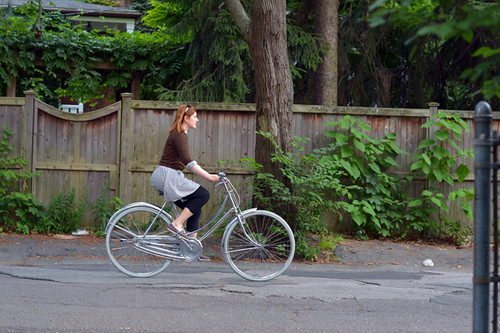
When I first started riding for transportation in Boston, my trips were about 2-3 miles each way and took me almost exclusively through relatively flat urban areas, bike trails, and quiet side streets. But as the nature of my work changed over the past few years, I found myself making more long distance trips that took me out of town. The change snuck up on me gradually. But when I look at my typical week today, a 20 mile round trip with some hills thrown in has become normal.
The effect of this on my choice of transportation bikes has been significant. I could not tackle most of my trips today on a heavy upright 3-speed geared for the city and still arrive at my destination energetic andpresentable - which is, after all, my priority. I need low gears for the hills; I need speed to cover the distance within a reasonable time. Naturally, these practical considerations have influenced my preferences.
On the other hand, the longer trips have not changed how I dress on the bike. I would describe myself as a low maintenance dresser, so I've never been one to wear carefully pressed pastel satin suits and stiletto heels in the first place. But I do wear mostly skirts and dresses - always have; it's just what I feel comfortable in. So far I've had no issue continuing to do that.
My views on the feasibility of cycling for transportation continue to expand as I ride longer distances. I still do not feel the need for a car. In fact, I enjoy traveling by bike now more than ever - the terrain is more varied, with less urban congestion. As far as challenges, time management is the biggest issue - with more careful planning required to get everything done by bike. Poorly plowed suburban roads in the winter will be a possible obstacle in future, though this past winter that was never a problem.
I am looking forward to writing more on this, addressing topics relevant for those with long commutes who still want to ride in their regular clothes.When I started out I never imagined that I would be doing this kind of cycling, yet here I am.
Has a changed commute altered your perspectives on transport bicycles, bike-appropriate clothing, and the feasibility of cycling for transportation?
Sunday, October 17, 2010
Preparing for Long Distance Rides
They say a good rule of thumb when working up to a long distance ride, is to ride in a week the number of miles you plan to do in a day. This morning I looked at my wall calendar (which now resembles a numerology chart) and realised that I've ridden around 200 miles over the past week, Saturday to Friday, distributed over the seven days as 16-60-0-0-24-40-60.
Today I feel all right. A little beat up, but no more than usual. Still, I am not convinced that doing this milage over the course of multiple days means that I can ride even 100 miles in one go. After a 60 mile day I am depleted to the point that in the end I cannot imagine being in the saddle a second longer.
And I take too many breaks. For instance, yesterday's milage was divided into: 8 easy miles alone/ break/ 20 hilly miles with a fast partner/ lunch break/ 24 hilly miles with a fast partner/ break/ 8 easy miles alone. Is it even fair to call that a 60 mile ride? The longest I've done so far in a group without breaks has been a measly 35 miles.
I don't like the idea of "training," and prefer to think of these rides as preparation. I never want to get to the point where I hate being on the bike and have to force myself to ride. What I like about the past week is that I've managed to not only put in 200 miles, but to feel good about it. What I don't like, is the limit I am sensing: After 60 miles I just don't feel that those remaining 40 are in me.
How do you prepare for long distance rides? Is it normal to feel a daily milage ceiling past which you can't seem to advance?
Thursday, October 14, 2010
Remembering the one and only Ted Cox!
Last Sunday Mount Rainier National Park and the Rainier Climbing Community lost yet another long time friend. The following is from our Chief Ranger Chuck Young and former climbing ranger Mike Gauthier. Thanks Guys. A memorial service honoring the life of Ted will be held this coming Thursday, August 16th around 6 pm at the Community Building in Longmire, WA. Everyone is invited to come and help us celebrate the life of our friend. It is a potluck so along with stories bring some food and beverages to share. If you would like more details about the location or event please email us, we will try to be timely in our response.

We are saddened to report that MORA Protection Division employee Ted Cox
has passed away from complications related to an aggressive form of
cancer. Ted, 70, passed away this Sunday in the company of dear friends
and loved ones; he had worked for the past 10 years as a seasonal Trails
Laborer at Camp Muir.

Ted’s career at Mount Rainier was defined by meticulously taking care of
the waste and water systems for Camp Muir, arguably one of the world’s
most difficult utility systems to maintain.  He did so with pride,
dedication, and joy, which earned him the unofficial and affectionate
title of "Mayor of Camp Muir."  By doing his duties so well and with
such disarming charm, the climbing rangers were better able to focus on
the pressing needs of public safety and resource protection. Each week
in the late spring and summer, Ted began his work shift by hiking to the
10,000 foot high camp where we would reside for four days. Each trip, he
would pack and haul heavy loads of supplies and materials; often he
performed arduous and physically demanding tasks at high altitude which
is always an impressive feat. This is something that Ted did with
gleeful pride up until his diagnosis this June.

With a playful and light-hearted grin, Ted often said that maintaining
the critical waste system at Camp Muir was his “life’s work.” He was
serious about that too, as he loved the mountain community and the
unique personalities that he would meet day to day.  Ted did more than
just maintain a utility system, however; he also cared for the staff as
a non-judgmental friend and confidant, and always kept the peace amongst
a dynamic crew of with equally dynamic personalities and situations. Ted
was the person that rangers and guides could rely upon to help maintain
cohesiveness and peace within the sometimes intense and stressful
situations that can exist at 10,000 feet.  Before Mount Rainier, Ted
worked at Olympic National Park in the maintenance division, and in the
off-season, lived in Sequim, WA and in Talkeetna, Alaska.    He will be
sorely missed by the guides, rangers, his friends, and the public who
had the good fortune to meet Ted at Camp Muir or while hiking up or down
from Paradise.
Wednesday, October 13, 2010
Long Island Sunset

As its name implies, Long Island is a very LONG but narrow island in the Susie Islands. Only about 100 feet wide at its widest point, it is roughly one half-mile in length. This photo was taken at sunset over the East end of Long Island.
Sunday, October 10, 2010
Almost Wordless Wednesday :: Anticipation


Monday morning as I walked out to the mailbox I noticed that the daffodils were starting to pop up through the mulch in my little flower garden. They sure do grow quickly! The first ones that came through are now about 3" high and more are coming up. These pictures were taken this morning, Wednesday March 18th. Winter is nearly over, Spring is only two days away!!
The ice return

Laura and I decided to take the trip toour local cliffsto see what we could climb. We found that the ice has mostly recovered from the warm snap,although most of the longer routes need a little more time to be safe. The weather forcast calls for cooler temps this week and by next weekendmost linesshould be in great condition. We ended up getting a late start and only did one line, but we sure did pick a good one. The line was about 150' long and had some serious funkiness to it. The bottom was nice and phat (but took much removal for good reliable sticks).As I got towards the middle of the route the pillar got worse with very new unreliable surface ice. A nice rest made above this section made the final push to easier ground very doable. The upper section was very thin and didn't take very good screws. The last 20' of steepness was a horrorfest of hollowed out shit from the previous freeze. The final topout was an overhanging lipconsisting of sloppy mud on my right andon my left was a 300+lb block of oldice with nothing but 10" of air between it andthe wet rock.Not really sure what was holding it in place. My last piece of gearwas 15+ feet below me. It was my last long screw into a blob of ice not fit for the using.It made it toabout the 4th thread. After a serious hesitation, mental prep.and almost sharting in my goretex, I commited to the final moves of mud and deathblocks.It seemed like an eternity, but I made it to the tree and slung it with pride.Iwas happy to be standing in 3" of muck and water for my belay. I cringed as I peeped down over what I had just overcome. I swapped golves to bring life to my hands. They were wet and cold from being onthepitch for 1hr. and 15min. I'm sure Laura was freezing from her extended belay session, so I quickly put her on and got her climbing. She did very well coming up the steep section and made quick work through the easy section. The top proved to be tricky for her as well as she rolled herself onto the top, muck and all. No style points, but success was ours. We setup a rap madeour way to the ground. Wedecidedone was enough and opted to head home. Our day was not without incident though.I ended up gettingnailed by a UFO on the back while cleaning upropes. It left a nice knot on my back. Wrong place, wrong time. All in all it was a great day. Wedubbedtheline G Gully WI5- with fullpucker rating for the topout in current conditions. Here's a few photos from today!


Friday, October 8, 2010
Pig Figurine

My dad brought me this pig playing a flute when he came back to Texas after being stationed in England for a year about 1955.
On your mark, get set, ready?
 It's almost time for the Opening Ceremonies! The Genea-Blogger Group Games (henceforth known here as "The Games") officially begin on Saturday with genea-bloggers from around the world participating. Consisting of five categories with various tasks to be performed, The Games will certainly be a challenge. I'm looking forward to these games and "meeting" some of the new Genea-Bloggers. I'm also looking forward to those "other" games that will be going on at the same time!
The five categories of "The Games" (and my goals) are:
1. Go Back and Cite Your Sources!
One of my resolutions this year was to "clean-up" the sources in my databases. It's one of those items that hasn't been started yet. I'm planning to download Legacy 7.0 soon and am hoping their new sourcing templates will help make the job a bit easier.
2. Back Up Your Data!
I'm fairly confident that I'll be able to accomplish several of the tasks listed but the last two are way out of reach for me (too much stuff has been collected over the years).
3. Organize Your Research!
I've slowly been working on this but still have a long way to go. My major project this summer has been organizing and scanning family photographs. All those genealogy documents are still waiting for me so maybe "The Games" will kick-start the process.
4. Write, Write, Write!
I think I'll go for the gold on this one! Which three will it be?
5. Reach Out & Perform Genealogical Acts of Kindness!
Three should be doable here as well. I like gold. But Diamonds and Platinum would be nice too.
A special "Thank You" for all their work goes out to Miriam Midkiff, Kathryn M. Doyle, and Thomas MacEntee. They are responsible for organizing the Genea-Blogger Group Games and I'm sure they have expended considerable time and energy in doing so. In addition, footnoteMaven is also to be commended for providing the very fine logo being displayed by participants. fM has also created the "medals" that will be awarded during the Closing Ceremonies.
=+==+==+==+=
Updated 6:45 PM - Check out the Opening Ceremonies of the Summer .. Genea-Blogging Group Games: The Parade of Delegates for a listing of all participants and the flags that represent them!
The meeting of Earth and Sky

Crazy cool, INCREDIBLE northern lights last night! What made the night totally unforgettable was not only the lights but the music of nature. Spring peepers and wood frogs were calling all night long and while I was shooting over a lake I could hear a barred owl calling from across the lake. It was one of the best nights I've ever spent in the woods with my camera! For the first hour of viewing, the Aurora held the form that you see in the photo above. To me it sort of resembled the funnel cloud shape of a tornado. This photo was taken at about 11:00 PM. A couple of hours later the scene was totally wild as the lights easily filled 75% of the sky and were moving much, much faster than they were when the above photo was made. The lights shown in the photo above were hardly moving at all. The variety that exists in the lights of the Aurora never ceases to amaze me!

The last few times I've gone out shooting the Aurora I've been trying to get more creative with some of my compositions. I've been trying new locations as well as new perspectives. The above photo is one such perspective, with the lights reflecting in the lake and the top corners of the image framed by pine branches. I personally really like this composition. To me it feels like I am looking through a window out into the scene beyond.

This was such an incredible night of photography, it's hard to imagine being able to top it. Between 1:00 and 2:00 AM the lights were some of the best I've ever seen. At the time the photos below were taken, the lights were flickering incredibly fast and it felt as though they were actually touching the tops of the trees. They were emanating from the sky directly overhead and washing down over the surrounding landscape. Indeed, the Earth felt connected to the Sky that night.


Blue Ice Warthogs are back in stock...
 Photo courtesy of Dave Searle collection
I have a good numberof the Warthog packs back in stock. Pre-orders wereshipped today.If interested you can order onehere:
http://coldthistletools.blogspot.com//04/blue-ice-gear.html
Thursday, October 7, 2010
By the Sea in Dún Laoghaire

Pronounced "Dunleary," with an emphasis on the second syllable, Dún Laoghaire is a provincial seaside town in Ireland just south of Dublin. I am visiting family here before going north to County Antrim, and will return here again afterward before flying back to Boston.
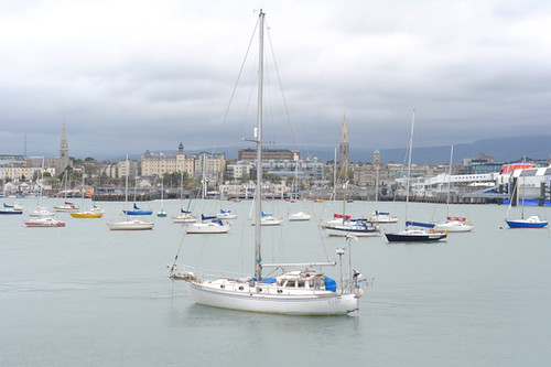
I love small seaside towns and was excited for this to be my first introduction to Ireland. Arriving to a new place, we never really know what to expect. This time the unexpected part was the familiarity. If you can picture a cross between Brighton, England and Portland, Maine with a touch of South Boston's waterfront area, you will be well on your way to forming a picture ofDún Laoghaire. Growing increasingly suburban as it stretches inland, there is a dense commercial center closer to the sea. Streets are generally narrow, with a system of even narrower hidden alleyways that are used as pedestrian shortcuts. The exception is the wide and highly traveled road that stretches along the waterfront. A sidewalk promenade follows the road with occasional interruptions and everything here is built on a large scale: a towering city hall, a string of grand hotels, an enormous modern theater.
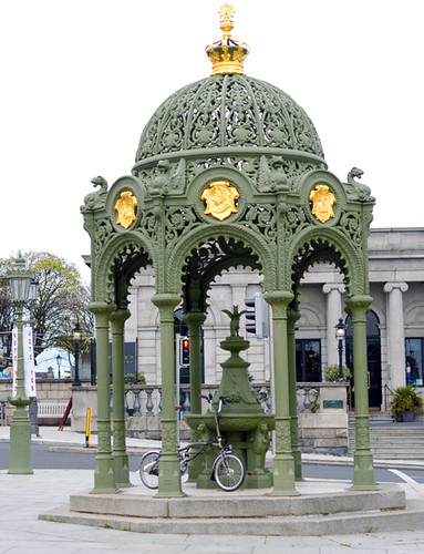
Dún Laoghaireis not an old town, and a lot of the design elements can be traced to the Victorian and Edwardian eras. Iron latticework, gilded pavilions, hotel walls painted in pastel hues.
Walking along the waterfront, it is easy to imagine the heyday of this place. I can practically see the ladies in corseted frilly dresses strolling up and down the promenade with their parasols and lap dogs.
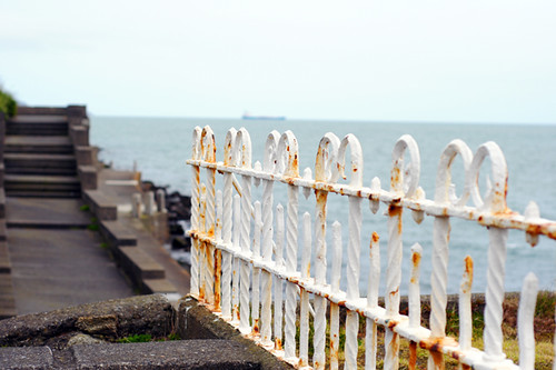
Of course now it all looks a little shabby. Peeling paint, rust. And on a drizzly weekday, the only people I saw along the promenade were hooded joggers and a couple of young mothers pushing strollers while talking on their mobile phones.

Not that this detracts from imagining what the place used to be and what motivated people to create things like this elaborate minuscule pavilion.

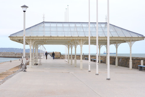
The distinguishing feature of the Dún Laoghaire waterfront is its two long granite piers. These start on the opposite sides of town, then curve inward until their tips almost meet. There is a red lighthouse on the East Pier and a green one on the West. It's as if they are looking at each other longingly across the water.
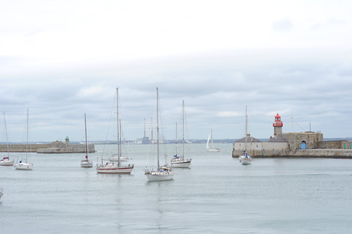
This charming view is, however, somewhat subverted by the intrusion of the Dublin Power station towers smack in between the lighthouses. You can see them in the distance here if you look closely.

There is much more toDún Laoghairethan this vast and quaint waterfront area, and in fact I haven't really described the town itself at all. But somehow the presence of the promenade, with its granite piers and rusting latticework and sea air permeates the rest of the town.The people are friendly, but reserved. An elderly man in a pub said to me that those who enjoy living here value anonymity. Otherwise they are miserable and can't wait to leave. So close to Dublin, this town does not feel as if it's anywhere near a capital city. It is its own universe, hidden in plain sight; a closed system.
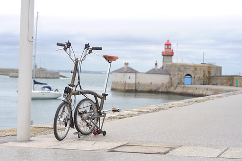
I have been cycling despite the non-stop rain, mostly for transportation and exploring. The cycling is so-so. No bike lanes at all, but the roads are mostly calm except in the town center. I am not entirely comfortable with the left-handed flow of traffic yet, so I am afraid to ride on busy streets and sometimes take the sidewalk (as do half the cyclists here it seems). Cycling along the endless East Pier in a light drizzle and enjoying 3/4 water views has been my most memorable ride so far. I don't mind the rain and the cold here, but it does make taking good pictures difficult.
Overall I am trying to decide whether I like it in Dún Laoghaire. Is this the sort of place I'd want to live? In theory, it really should be. It's got the sea, mazes of narrow streets, stone houses, lots of wild vegetation, privacy, and genuinely pleasant people. But for some reason, it doesn't quite pull at my heart strings. I am comfortable here and do not even experience my trip as being abroad so far. But I feel a little detached from this town. Tomorrow I take the train to the North of Ireland.
Subscribe to:
Comments (Atom)