On arriving back in Clatskanie, Oregon we found Jan's dog, Paddy, more than happy to go home from the Happy Hound Dog Kennel. I think we were a bit glad to get back, also. It had been a long 3 day trip even if it had been thrilling, exciting, interesting, and exceptionally beautiful. I would recomment a trip to the Olympic National Park to any one. All the places where wonderful to visit with lots of great places to visit. We had gone over a weekend during the summer and it did not seem as crowded as I had expected. And everybody we met, either Park personal or visitors were very friendly.
Stop worrying so much. Worry will not strip tomorrow of its burdens, it will strip today of its joy.
Monday, February 28, 2011
Back to Clatskanie
On arriving back in Clatskanie, Oregon we found Jan's dog, Paddy, more than happy to go home from the Happy Hound Dog Kennel. I think we were a bit glad to get back, also. It had been a long 3 day trip even if it had been thrilling, exciting, interesting, and exceptionally beautiful. I would recomment a trip to the Olympic National Park to any one. All the places where wonderful to visit with lots of great places to visit. We had gone over a weekend during the summer and it did not seem as crowded as I had expected. And everybody we met, either Park personal or visitors were very friendly.
Saturday, February 26, 2011
Off Road on the Edge of the World

A couple of days ago I accidentally completed a 6 mile off road ride along the coast of Antrim. Without question, this was the most challenging bike ride I have done to date. I would not have attempted it had I known what was in store for me. But it was also the most beautiful, breathtaking trail I have ever been on.

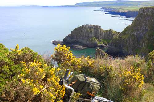
It happened like this: One morning I decided to ride to the Giant's Causeway, which is about 12 miles away. I took the direct route on the coastal road. The first part was a tedious climb, then a long descent - both with glorious water views. When I was almost at the end, I spotted a sign for Dunseverick Castle and stopped to have a look. The setting is very interesting, and I walked around a bit photographing it. The light kept changing every 5 minutes, so the colours in all my pictures from this day are crazy and I decided to leave them that way. The landscape here really can look neon green one moment, then golden or drab olive the next.

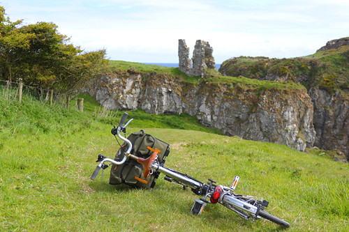
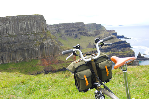
Like most structures described as "castle" along the coast of Northern Ireland, Dunseverick Castle is actually a ruin. There is an overview platform from which visitors can observe it from the road (people do coastal driving tours here...). And next to this platform is a sign indicating that there is also a walking trail - leading down to the castle, then continuing right along the coast to the Giant's Causeway.

I looked at the trail. It was grassy and appeared pretty tame. The Giant's Causeway didn't seem that far off. So I decided to go for it on the bike.

The trail ended up being 6 miles long, with no exit points along the way. As far as cycling, I would describe it is as not for beginners. I spent maybe 40% of it on the bike and the rest walking, or crawling. The initial stretch of grass quickly narrowed to a rocky, twisty single track along the edge of a massive cliff overlooking the Irish Sea.

There were also long stretches of loose, chunky gravel. There are no flat, straight sections along this trail - it is either uphill or downhill, and all twisty. Honestly, I found the terrain extremely challenging. Going toward the Causeway, the trail is mostly downhill and the ground beneath me was unstable due to the mud, roots, rocks and loose gravel. It was scary to experience this combined with constant twists and turns as I cycled alongside a cliff. Also, at some point the hub gearing on my Brompton started coming out of adjustment (now fixed), and I did not always have use of my lowest gear. This made some of the uphill sections on loose gravel impossible, so I walked them. I also walked a couple of the trickier downhill stretches. An experienced mountain biker could have maybe done 80-90% of the trail on a bike, but I am far from that status.

It did not bother me to walk with the bike when that was what I had to do. I had a heavy bag with me, and I was glad to roll it along on wheels rather than carry it on my person, as I would have had to do had I chosen to hike this trail. Despite the stunning views along this trail, there were not many hikers around. Most of the time I was completely and utterly alone, with no other human forms visible in any direction. I encountered three groups of ramblers total, and they all expressed horror at seeing me with a bike. "You need to turn back," a German couple warned, "it is not bike territory ahead." I knew exactly what they meant, because I had already gone through that kind of territory.

Along this trail there are occasional stairs built into the hills. They look like this, sometimes worse (longer and steeper). There was one particular set of stairs where the grade was too steep to walk upright, so I had to sort of crawl up them with the bike on my back.

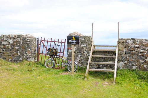
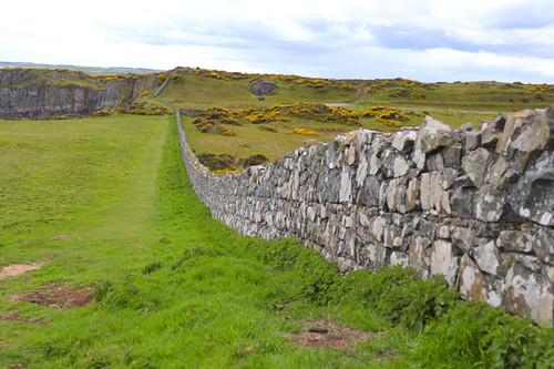
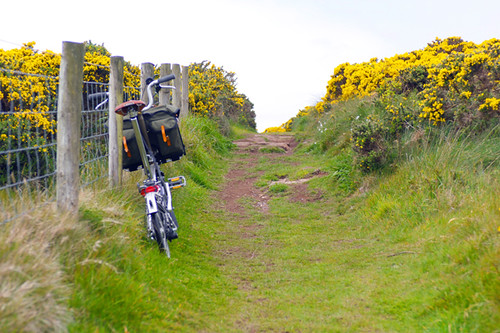
Since the trail passed through farm territory, there were also occasional stone fences with stiles to climb over - essentially wooden ladders placed over the fence. These were a little shaky, so I had to hold on to a pole with one hand (taking care not to grab the barbed wire instead - of which there is lots) while carrying the bike in the other. All through this, it was of course freezing cold and raining intermittently.

Well, what can I say. One must have a sense of humour about things like this. Sure, the description of the trail could have warned there would be crawling and flights of stairs involved. But that would have spoiled the surprise element, wouldn't it. Ultimately it was more engaging to "discover" the trail this way rather than reading all about it in a guidebook first.

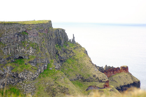
The day was hazy and my photos don't do the landscape justice. But this hidden gem of a trail showcases the raw beauty of the Antrim Coast better than any other site I have visited so far. It is extreme. It is dizzying. And not just the heights alone, but the colours, the smells, the forms and textures.

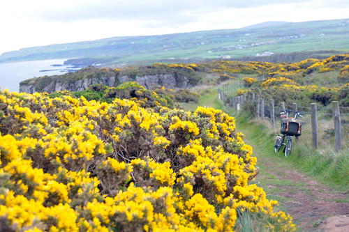
And it truly does feel like the edge of the world:The trail is set back from the road by endless glens. You cannot see civilisation; only the edge of a cliff on one side of the trail and pastures on the other.

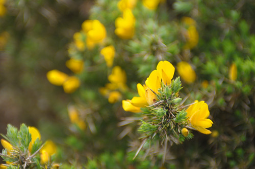
Gorse bushes grow everywhere, their saturated yellow contrasting dramatically with the steel-gray sky.

It took me over 2 hours to get to the end of the trail, including all the climbing over fences and stairs, as well as constant stops for photos. By the time I reached the end point, I was exhausted and badly in need of food. The funny thing is that when I got to the Giant's Causeway itself it was absolutely unphotographable: Every inch of the majestic formation was covered with tourists. How odd that people will drive to it just to get out of the car for 5 minutes and have their picture taken on the rocks, but ignore the stunning trail that showcases the full extent of this area's beauty. Also, the entire site next to the Causeway is covered in construction at the moment. They are building a new, enormous visitor's center and while this is happening the area is a chaotic tangle of construction crews and tour buses and hordes of disoriented visitors. Dust flying everywhere. Yikes. I quickly bought an ice cream and got the heck out of there, deciding that I'd come back to see the Giant's Causeway at 6am next time to avoid the crowds.

The trail from Dunseverick Castle to the Giant's Causeway is technically a hiking trail, not a bicycle path. In truth, it is more suitable to hiking unless you have nerves of steel and serious cyclocross skills. Still, I am glad I did it this way and I admit that I feel a tremendous sense of accomplishment (I also still feel wrecked 2 days later, but that is another story). As far as the bike's suitability, I find that the Brompton rides surprisingly nicely off road and is easy to control on downhill turns, so if anything I am more comfortable on challenging terrain on this bike than I would be on others. Another obvious advantage of the Brompton on a ride like this, is that it is small enough to carry when necessary. I would not have been able to drag a full-sized bicycle (especially a mountain bike) up and down those stairs and over those stone walls. Next time I visit this trail, I might hike - or I might do it exactly the same way but try to stay on the bike more. This was by far the most difficult ride I have ever done, but it was also the most rewarding. When the two go hand in hand, it is pure magic.
Man Fashion Friday
3/4 Pant - models own design 100% nylon, gusseted climbing pant,tailored in Shenzhen, China for jjobrienclimbing.
Shirt - models own design,100% silk, with gold thread brocade, reclaimed Idian Sari fabric. Tailored in Shenzhen for jjobrienclimbing.
Glasses - Shanghai Tang HK
Croc knock offs - HK street market
Location Coolum Cave.
OMG is that international Aussie rock star Lee Cujes?Model looks hot in:
Jeans: by G Star Raw
Inner
Faux leather bomber:unpurchased I suspect,
by the dead stock and sample cult mega-label"Mee and Gee" of Hong Kong
Glasses: unknown
Location: Mee and Gee, Tung Choi Do HK(upstair for man)
Photo: Sam Cujes, on Lee's iPhone presumably
Welcome home to Australia, Lee and Sam.
Wednesday, February 23, 2011
Onsight!
Simon Carter has been responsible for so many of us taking up the life of climbing.
Climbers, you remember the first time you saw a Simon Carter photo. We all had the same experience. The urgent, desperate need to buy some gear and get out there. It was a glimpse of what was possible.
So when he put on a show in Brisbane in July everyone and their belayerturned up. I think the opportunity to get closer to the source of our inspiration was irresistible.
That, and Monique Forestier, who is currently smashing every hard route in this corner of the State.
Monique supported the team on the night with a beautifulRed Phoenix Emporium bespoke necklacefeaturing Tibetan turquoise.
Over 150 people were entranced by the best climbing shots from around the world.
In the collageyou'll see Andrew Lightfoot, Rob Saunders, Duncan Steel, Brad Babel, Simon Carter, Bochere Rand, Tracey, Henk, Sam and Lee Cujes, Suzy G, and more


But it's not all about the climbing. We blew the morning off fooling around at the beach with Cocoin the glorious winter sun.I lacked the basic timing skills to keep dry while getting water in the bucket.
I love the newBronsonpant. ThanksPrana and Expedition Equipment. If I had one tiny criticism it would be that the cuffs get a little heavy when they are full of sand and sea water. Not usually an issue at the crag.
Photo sequence: Simon Carter
Monique sent the always awesome Lee Cujes route, Gasoline Rainbow 28, without too much mucking around. I didn't have the chops for it this time. That route is way too much fun. So many funky moves.

Photo: Phil Box
Sterling Rope climber Monique Forestier gets some Velocity 9.8 between her teeth.

Photo: Phil Box

photo: Phil Box
A quick celebration back at the belay.
Photo: Selfie
And there goes the Coolum Classic, Screaming Insanity.

Thanks Simon and Monique for bringing so much fun and talent to the local crags.
P.S. Monique, moments ago, (10/8/) sent Whistling Kite 32 at Frog Buttress, making the first female ascent.
Cape Blanco
Monday, September 27, .. - - Cape Blanco State Park, eight miles northwest of Port Orford, Oregon.
Looking South from the top of the bluff.
This is why it is called Cape Blanco. As I drove up to the park, the sky changed from a beautiful blue to white and the temperature dropped eight degrees.
Within two hours the fog completely blanketed the area...
Looking South from the top of the bluff.
This is why it is called Cape Blanco. As I drove up to the park, the sky changed from a beautiful blue to white and the temperature dropped eight degrees.
Within two hours the fog completely blanketed the area...
Monday, February 21, 2011
Ed Cooper on Deltaform!
Many of the current generation of climbers may not know the name. But you should! Ed Cooper was climbing things years ago that many of us still aspire to today. He was likely there first either taking pictures or climbing some thing that most have not seen in North America yet unless you have gotten off the beaten track. FromDenali andEl Cap in the 50s to the "black hole" on the other side of the Canadian Icefields in the '60s. I am honored to present Ed's commentsand photos of Deltaform here on the blog. What a treasure, enjoy!

Interview with Ed here:
http://www.7photographyquestions.com//01/p35-show-notes-for-mountain-photography----an-interview-with.html
His website is here:http://www.edcooper.com/mountains1.html
Make sure you dbl click on the wonderful photos!
Ed's comments,
"I wouldn't describe Deltaform Mountain as an especially beautiful or aesthetic peak, but it is certainly an awesome mountain with a raw savage feel to it. It makes a great photographic study. Attached are several views of it, some with nearby peaks.They were all taken with a 4x5 view camera except for the view from the top of Mt. Lefroy, which was taken with a 2 ¼ x2 ¼ square folding camera. Low-res images are
included here, but the original scans are close to 300 megabytes each, enough to blow the images up to 30x40 inches and still maintain 300 dpi. Considerable restorative work was required on all the images, as over time the colors had faded, and fungal spots had appeared on the film emulsion."
"The north face has made my anti-bucket list; that is, I've added it to places I would rather not be. I have recalled two interesting anecdotes about this area."

"About the time the images taken in 1971, there was a fatal accident in the couloirs between Peaks 2 & 3 of the Valley of Ten Peaks. A climber was killed by a falling rock careening down the couloirs while he was ascending toward the Neil Cogan Hut located between Peaks 2 & 3. Sometime later, I happened to run across a climber that I knew, and he was very surprised to see me. He said, "I thought you were killed in the Valley of Ten Peaks area". It turns out that the climber that was killed had the last name of Cooper."

"The photo taken from the top of Mt. Lefroy has an interesting history behind it. It was the only time in my life that I have had a powerful premonition about a climb. This was a period in my life where I was exploring my inner self, with periods of intense meditation. In Augustof 1971, I met up with and joined a group of 5 other climbers to climb Mt. Lefroy.
We approached the Abbot Pass Hut via the "Death Trap". The next morning we headed out and traversed out below Mt. Lefroy, The unofficial leader of the group pointed up a snow slope that led directly to the summit with no interruption by rocks. He indicated that that was the route.
One look at it and I had an immediate foreboding and knew that I couldn't go that way. I expressed my feeling to the group, and one of them agreed to go with me up another route, close to rocks, to the right of the other climbers.
As we proceeded upward, we noticed snow conditions deteriorating rapidly due to the warm sun. Snow was starting to slough off and slide. We stayed as close to the rocks as possible and actually climbed on them where feasible. It was during this time that we heard some commotion and shouts off to our left, where the other climbers were. Once we had reached a perch where we could look to the left, we saw the other
four climbers near the base of the climb. It was obvious they had been caught in an avalanche.
There was nothing we could do at this point, as it was too dangerous to descend even the route we were ascending. At least two of the climbers were moving around, so we knew that they, at least, would be able to get back to the hut at Abbot Pass and call for help.
To make a long story short, we reached the summit (where I took the picture) and then proceeded eastward over unknown terrain to find our way down. We weren't prepared to follow a new route, and we wound up traversing many ledges below cliff faces in an attempt to get back to the hut. We had to rappel a few times. At some point we were aware of helicopter noise, which came in to rescue the most severely injured of the climbers.
We arrived back at the hut just as darkness was closing in, thankful that we had chosen a different route!"


Interview with Ed here:
http://www.7photographyquestions.com//01/p35-show-notes-for-mountain-photography----an-interview-with.html
His website is here:http://www.edcooper.com/mountains1.html
Make sure you dbl click on the wonderful photos!
Ed's comments,"I wouldn't describe Deltaform Mountain as an especially beautiful or aesthetic peak, but it is certainly an awesome mountain with a raw savage feel to it. It makes a great photographic study. Attached are several views of it, some with nearby peaks.They were all taken with a 4x5 view camera except for the view from the top of Mt. Lefroy, which was taken with a 2 ¼ x2 ¼ square folding camera. Low-res images are
included here, but the original scans are close to 300 megabytes each, enough to blow the images up to 30x40 inches and still maintain 300 dpi. Considerable restorative work was required on all the images, as over time the colors had faded, and fungal spots had appeared on the film emulsion."
"The north face has made my anti-bucket list; that is, I've added it to places I would rather not be. I have recalled two interesting anecdotes about this area."
"About the time the images taken in 1971, there was a fatal accident in the couloirs between Peaks 2 & 3 of the Valley of Ten Peaks. A climber was killed by a falling rock careening down the couloirs while he was ascending toward the Neil Cogan Hut located between Peaks 2 & 3. Sometime later, I happened to run across a climber that I knew, and he was very surprised to see me. He said, "I thought you were killed in the Valley of Ten Peaks area". It turns out that the climber that was killed had the last name of Cooper."

"The photo taken from the top of Mt. Lefroy has an interesting history behind it. It was the only time in my life that I have had a powerful premonition about a climb. This was a period in my life where I was exploring my inner self, with periods of intense meditation. In Augustof 1971, I met up with and joined a group of 5 other climbers to climb Mt. Lefroy.
We approached the Abbot Pass Hut via the "Death Trap". The next morning we headed out and traversed out below Mt. Lefroy, The unofficial leader of the group pointed up a snow slope that led directly to the summit with no interruption by rocks. He indicated that that was the route.
One look at it and I had an immediate foreboding and knew that I couldn't go that way. I expressed my feeling to the group, and one of them agreed to go with me up another route, close to rocks, to the right of the other climbers.
As we proceeded upward, we noticed snow conditions deteriorating rapidly due to the warm sun. Snow was starting to slough off and slide. We stayed as close to the rocks as possible and actually climbed on them where feasible. It was during this time that we heard some commotion and shouts off to our left, where the other climbers were. Once we had reached a perch where we could look to the left, we saw the other
four climbers near the base of the climb. It was obvious they had been caught in an avalanche.
There was nothing we could do at this point, as it was too dangerous to descend even the route we were ascending. At least two of the climbers were moving around, so we knew that they, at least, would be able to get back to the hut at Abbot Pass and call for help.
To make a long story short, we reached the summit (where I took the picture) and then proceeded eastward over unknown terrain to find our way down. We weren't prepared to follow a new route, and we wound up traversing many ledges below cliff faces in an attempt to get back to the hut. We had to rappel a few times. At some point we were aware of helicopter noise, which came in to rescue the most severely injured of the climbers.
We arrived back at the hut just as darkness was closing in, thankful that we had chosen a different route!"


Thursday, February 17, 2011
Childs Cup
These cups were very popular in 1950's. The little bird on the handle is a whisle and it says 'Whisle for Milk' on the bottom. This one was mine. I found them on line and they are worth about $5.00 now and sold for 39 cents orginally.
Wednesday, February 16, 2011
Cow Rubbed Tree Knot
This is my favorite knot of those on the trunk of the old juniper tree that I like so much and tell the story of in the following photos, and posts.
Monday, February 14, 2011
Yellowstone :: West Thumb Geyser Basin
Wednesday, August 31st - - After spending the night at one of the campgrounds in Buffalo Bill State Park west of Cody, Wyoming it was a relatively short drive (a little over an hour) to the eastern entrance to Yellowstone National Park. Then another 30 miles to the campground at Bridge Bay in the southeast portion of the east side. I had decided to give the park a “second chance” since simply driving through it last year just before the Fourth of July weekend. My visit this time was quite pleasant with less people, far less traffic, and much cooler temperatures!
After checking into the campground, which would be my “base” for two nights, I drove the southern loop through the park. My first stop was the West Thumb Geyser Basin, which overlooks Yellowstone Lake, the largest lake at high elevation (7,733 feet) in North America – it encompasses 131.7 square miles, is 14 miles wide and 20 miles long, with an average depth of 140 feet. In other words, it is HUGE! And beautiful, with the Absaroka mountain range on its eastern side.

The volcanic caldera at West Thumb contains many geothermal features including pools, springs, geysers, and paint pots. Above is a view of the central portion, which sits above the lake. The geysers, however, are currently in a dormant stage, thus no eruptions were seen.

The Abyss Pool is one of the deeper hot springs in the park, descending to a depth of 53 feet.

The trail guide states that Black Pool was, at one time, actually black. Cooler water temperatures allowed thick mats of dark green and brown thermophiles (heat-loving microorganisms) to grow in the pool, causing it to appear black. The water temperature rose during the summer of 1991, killing the organisms.

Walking alongside the pool on the boardwalk you could feel the heat from the hot water. At times, the steam rising from the pool was so thick you couldn't see the other side!

The water appears to be turquoise but it was so clear you could easily see portions of the bottom. There were several deeper areas – the “black holes” where the bottom could not be seen.

Interesting formations line the sides of the pool.

Constantly in a state of change, new features appear every day.

Hot water from Black Pool and other features in the area flows into Yellowstone Lake. The color variations are caused by those little thermophiles – microorganisms that thrive in the hot water.

Along the shore of Yellowstone Lake is this feature, called Big Cone. It's difficult to tell from the angle of the photo, but the cone rises about 12 inches above the outer surface.

Boiling hot water bubbles up in the Big Cone.

Further along the path and completely surrounded by water is the “Fishing Cone” so called because Mountain Men told of catching a trout in the lake, swinging the pole around, dipping the catch in the boiling pool, and cooking the fish without even taking it off the line! Sometimes in spring and early summer the Fishing Cone is underwater due to the rising lake waters from snow melt.
After checking into the campground, which would be my “base” for two nights, I drove the southern loop through the park. My first stop was the West Thumb Geyser Basin, which overlooks Yellowstone Lake, the largest lake at high elevation (7,733 feet) in North America – it encompasses 131.7 square miles, is 14 miles wide and 20 miles long, with an average depth of 140 feet. In other words, it is HUGE! And beautiful, with the Absaroka mountain range on its eastern side.
The volcanic caldera at West Thumb contains many geothermal features including pools, springs, geysers, and paint pots. Above is a view of the central portion, which sits above the lake. The geysers, however, are currently in a dormant stage, thus no eruptions were seen.
The Abyss Pool is one of the deeper hot springs in the park, descending to a depth of 53 feet.
The trail guide states that Black Pool was, at one time, actually black. Cooler water temperatures allowed thick mats of dark green and brown thermophiles (heat-loving microorganisms) to grow in the pool, causing it to appear black. The water temperature rose during the summer of 1991, killing the organisms.
Walking alongside the pool on the boardwalk you could feel the heat from the hot water. At times, the steam rising from the pool was so thick you couldn't see the other side!
The water appears to be turquoise but it was so clear you could easily see portions of the bottom. There were several deeper areas – the “black holes” where the bottom could not be seen.
Interesting formations line the sides of the pool.
Constantly in a state of change, new features appear every day.
Hot water from Black Pool and other features in the area flows into Yellowstone Lake. The color variations are caused by those little thermophiles – microorganisms that thrive in the hot water.
Along the shore of Yellowstone Lake is this feature, called Big Cone. It's difficult to tell from the angle of the photo, but the cone rises about 12 inches above the outer surface.
Boiling hot water bubbles up in the Big Cone.
Further along the path and completely surrounded by water is the “Fishing Cone” so called because Mountain Men told of catching a trout in the lake, swinging the pole around, dipping the catch in the boiling pool, and cooking the fish without even taking it off the line! Sometimes in spring and early summer the Fishing Cone is underwater due to the rising lake waters from snow melt.
Subscribe to:
Comments (Atom)